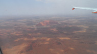
Uluru from the plane |
Jetstar in the airport |
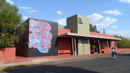
Aboriginal woman with paintings |
Hotel Lost Camel*** |


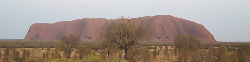
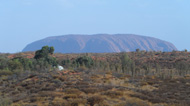
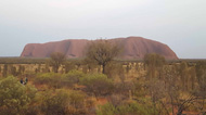
Uluru (Ayers Rock) |
Palya (welcome in the local language of Uluru) is the first word you see on arrival at the airport
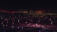
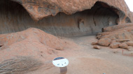
Uluru, o Ayers Rock, is a huge sandstone monolith in the heart of the arid "Red Center" in the Northern Territory. The closest town is Alice Springs, 450km away. Uluru is sacred to Australian Aborigines and its formation is thought to have started about 550 million years ago. It is located within the Uluru-Kata Tjuta National Park, which also includes the rock formation of Kata Tjuta (in colloquial language, "The Olgas"), consisting of 36 red rock domes. Surrounded by the completely flat surface of the bush, Uluru is visible from tens of kilometers away and is famous for its intense red color, which changes in a spectacular way (from ocher, to gold, to bronze, to violet) according to the time of day and season; characteristics that make it one of the icons of Australia. The surface, which from a distance appears almost completely smooth, reveals many springs, pools, caves, peculiar erosive phenomena and ancient paintings as you get near. Uluru is the original aboriginal name of the place. It is thought to derive from the word ulerenye, an Arrernte word meaning "strange". It is also a common surname in the area. The first non-indigenous to sight the formation was the explorer Ernest Giles, in October 1872. He saw the massif from very far away, and was unable to get any further because of Lake Amadeus. Giles described Uluru as "a remarkable stone" (an expression that was not adopted as a name, unlike what happened to the remarkable rocks of Kangaroo Island). On July 19 of the following year, William Gosse christened Ayers Rock in honor of the then Premier of South Australia Sir Henry Ayers. In 1993 a double denomination was formally established according to which both the Aboriginal and English names were considered official names. On December 15, 1993, Uluru was renamed Ayers Rock/Uluru and became the first dual name resort in the Northern Territory. On November 6, 2002, the dual name was officially reversed, becoming Uluru/Ayers Rock at the request of the Alice Springs Regional Tourism Association. Currently, the original Aboriginal name is the most used to indicate the rock, while "Ayers Rock" is used only to indicate the relative airport. Uluru is called a monolith, but more precisely it is a part of a monolithic rock formation, composed of a huge block of sandstone rock, much larger and largely underground which also includes the Kata Tjuta and Mount Connor. The Uluru stands out for about 350 m. compared to the surrounding area and sinks into the ground for about 7 km; has an altitude of 864 m a.s.l .; it has a circumference of about 9 km, and is characterized by a very hard surface and extremely smooth overhanging walls. A notable feature of the massif is the way it seems to change color at different times of the day and in the different months of the year; sunrise and sunset, in particular, produce extremely spectacular fast color variations (probably Australia's biggest tourist attraction). These color effects are due to minerals such as feldspars which particularly reflect red light. The massif is made up largely of iron and its red color is due to oxidation. Near the western end of Uluru is the Aboriginal community of Mutitjulu (pop.about 300). The local population is called Pitjantjatjara or Anangu (which means "people" in the Pitjantjatjara language). The tourist village of Yulara (pop. 3000) is located 17 km away, just outside the National Park. 25 km from Uluru are the Kata Tjuta mountains, literally "many heads", which are part of the same rock formation and have a similar red color. The Pitjantjatjara and Yankunytjatjara call tourists who go to visit Uluru and the Kata Tjuta minga tjuta, which means "ants", so as to describe the image they give from the top of these formations. The Aborigines have repeatedly requested that tourists do not climb the massif, both because it is a sacred place in the Aboriginal mythology of the Dream Time, and for security reasons. In 1983, Australian Prime Minister Bob Hawke promised that he would ban climbing. However, when the Australian government returned the property of Uluru to the Anangu (on October 26, 1985), the two conditions were placed that for 99 years Uluru was jointly managed by the national association "National Parks and Wildlife" and that during this period tourists were allowed to climb the rock. The climb of Uluru is in fact a very important tourist attraction, and above all very appreciated by the Japanese, who make up a significant percentage of the tourist population in Australia. Although a handrail (extended in 1976) was placed on the rock in 1964, the ascent is still quite dangerous due to the steep and smooth surfaces, the fatigue of the climb (which lasts about an hour) and, at least in a few hours and seasons, the risk of insolations; heart attack is among the leading causes of death. Starting from 25 October 2019 it was officially forbidden to climb the massif. There are several excursions that can be done in Uluru. Definitely worth the 1.5-hour night excursion that takes tourists to enjoy the splendid Fields of light show. Huge surface not far from Yulara, towards Uluru covered by 300 thousand unit lights. More than 380 km of optical fiber has been used in the installation. The author of the immense work is the British artist Bruce Munro who lives in London. The entire installation weighs 15 tons transported to Ayers Rock via 32 international and domestic flights. Qantas is the official sponsor for Fields of light, with Qantas cargo responsible for the transportation of the delicate 50 thousand individually produced light stalks. The most exciting experience, however, is to go around the monolith on foot, 10 km that can be covered in about 3.5 hours, having time to stop, take pictures and rest. Due to the temperature, we leave the hotel at 5 in the morning with a shuttle that takes us to a certain point to admire the sunrise (the colors change as the light appears), then we continue to Uluru, and around 6 you arrive at the parking lot at the foot of the monolith where you are left free to go around alone. At 10.30 the shuttle passes to pick up tourists. At this time the temperature was already over 40° C. Due to the high temperature at 11 the paths around the monolith are closed. The tourist area with some hotels is Yulara. The hotels are all fairly close. The Lost Camel Hotel *** is right in the center of the village represented by Times Square where there are a bar, two restaurants, shops, a supermarket, the post office and the bank. A free shuttle bus runs approximately every 15' to the various hotels. Upon arrival at Ayers Rock airport, all visitors are brought to the various hotels with free buses (around 15 minutes transfer). The best hotel in the area is the Sails in the Desert *****.