 |
Famous during the ancient times as "the land of a million elephants", and to the journalists of Indochina war as "land of a million insignificant persons", Laos is a rich mosaic of ethnical groups coming from all region of south-east Asia . And whereas the french influence still survives in the ex colonial districts along the Mekong River, on the slopes of the most sacred mountains of the country the believers still frequent the stone temples that date back to the magnificent Angkor empire. But maybe the most important merit of Laos is to have been capable to preserve big incontaminated natural zones. This has been conquered with difficulty after four centuries of discontinuos wars with the neighbouring countries and with the superpowers of the cold war. After the symbol of hammer and sickle inherited from the soviets was removed, Laos took its destiny in its own hands and adopted a free market that attracts a constant flow of investors from every part of the world. This country is very appreciated by the travellers that preferred it to the rest of the south-east Asia. According to a laotian person that has travelled all over the world and was far from his country for more than twenty years, "this is one the last quiet countries in the world".
In general the best period to visit Laos is between November and February: these are, as a matter of fact, the months with the least rain and when it is not still too warm". Under the tourist point of view the country is generally cheap.
Laos has a surface of 236.800 sq. Km. and a population of 5 million 600 thousand inhabitants (data 2001). The official language is lao in the spoken and written form in Vientiane. As official language, lao successfully became a frank language used for the relations between the different ethnical groups of lao and not-lao in the country. There are five main dialects, and each of them can be splitted into different local variants. All the lao dialects are closely connected with the spoken languages in Thailand, northern Myanmar and in some zones of the chinese province of Yunnan. About 60% of the population practices the theravada buddhism. It is foreseen that all Laotian buddhist of male sex are monks for a short period of their life, that usually corresponds between the end of the school carreer and the beginning of the work or marriage. The hmong-mien tribes practice the animism and the ancestors' cult. A small minority of Laotians, mainly made up of the élite that studies in the french schools, is of christian faith. The traditional laotian culture is strongly influenced by different khmer, vietnamese and thai currents. The Low Lao have the same ancestors of many thai tribes, consequently the similarity between the laotian and thai cultures are particularly strong, as it appears evident in the sculpture, in the classic music, in the danced dramas and in the Laos cuisine. The inhabitants of Laos are still skilful woodcarvers and weavers, whereas the arts of silver and gold manufacturing are by now desappearing. The main element of all the laotian meals is the rice and almost all plates are prepared with fresh ingredients like vegetables, fresh water fish, chicken, duck, pork or buffalo. The rice whisky or lào-lào (liquor speciality in Laos) is a very common drink among the plane populations. Generally it is drunk straight, accompanied by a small glass of natural water.
In the last years Laos became a favourite destination for the trip lovers in the south-east Asia. After the local authorities, in 1989, took the decision to open for the first time the gates to tourism, and thanks to the recent elimination of many bureaucratic restrictions and to the proliferation of hotels and guest-houses, trips to Laos became simplier and cheaper than in the past. The government lately established that tourist visa can be requested and obtained in any entry of the country: 30 USD. We remind you nevertheless that visas issued at the arrival allow a two-week stay in the country, viceversa it will be possible to remain one month if the visa is requested before departure.
One third of the present population of Laos lives in towns located along the Mekong valley, and mainly in Vientiane, Luang Prabang, Savannakhet and Paksè. Another third lives in the vicinity of other important rivers as Nam Ou, Nam Seuang and Set Don. Laos has been often defined as a conglomerate of tribes and languages rather than a nation. Gli Laotians themselves usually divide the country population in four ethnical groups - lao loum, lao thai, lao thoeng and lao soung - according to a distinction that is based on the altitude of the zones where the different groups live, and that thinks to reflect the respective cultural features. Almost half of the population belongs to the lao ethnical group, that is lao loum. The laotian government reduced to only three groups the traditional subdivision in four, inserting the lao thai in the lao loum group. This division can be found on the back of the 1000 Kip banknote, where three men are represented dressed with their own traditional costumes, on behalf of lao soung, lao loum and lao thoeng from left to the right. Laos is without access to the sea, and 70% of the territory is covered with mountains and plateau. The range of the Annamiti is located side by side along the Mekong river and covers about half the length of Laos, with peaks between 1500 and 2500 meters. To the centre of the range rises the Tableland of Khammanuan, a zone rich of wonderful gorges and limestone grottos. At the southern end of the range the Bolaven plateau is located, with a surface of 10 thousand sq. km., and represents an important zone for the cultivation of the mountain high-efficiency rice, coffee, tea and other agricultural products suited for the altitude cultivation.
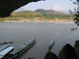
Luang Prabang
Luang Prabang
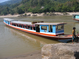
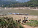
In order to have an idea of Laos in a relatively short period, the best itinerary is surely to enter the country by boat from Chaing Khong, in Thailand. You reach Houey Xay, just in front, where you can apply for the visa, which is issued at the moment, and with a local boat you can travel along the Mekong River from Houey Xay to Luang Prabang (about 300 Km.), with an overnight along the way in Pakbeng. During the navigation it is possible to enjoy a wonderful landscape made up of small villages, steep limestone slopes, forests and a moltitude of sandbanks with buffalos along the river. Before arriving in Luang Prabang it is possible to stop in Pak Ou to visit the caves with many buddha statues, and in the village Ban Xanghai where it is possible to buy local souvenirs and see how to produce the laotian whisky, the lao-lao.
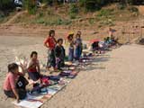
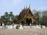
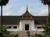
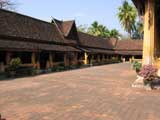
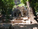
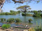
Luang Prabang is a small town of 30 thousand inhabitants and nowadays has become one of the main tourist zones in Laos. It is surrounded by mountains and is located at 700 m. above sea level in the confluence point between Nam Kham (river Kham) and Mekong river, and thanks to the presence of the temples with glittering roofs, of decadent palaces in provincial french style and a multiethnic population, the town can enchant even the inhabitants used to everything. On the streets of L.P. you could often meet people of hmong, mien and thai ethnical groups, that go and come from the markets. The monks and the buddhist novices wrapped in their orange tunics occupy 32 among the 66 historical temples built before the french colonisation, including the wonderful Wat Xieng Thong, dating back five centuries. L.P. boasts also a palace transformed into a museum unique in its gender. In the town the sense of peaceful antiquity is still so well preserved, that has brought to town the first visitors when Laos opened to tourism in 1989. L.P. remains a relatively calm place where at 10.30 p.m. most of the inhabitants are already sleeping. The town was the capital of the reign of Laos until 1545, when the king Phothisarat transferred the administrative seat in Vientiane. Furthermore, the insertion of the town in the list of sites considered a Mankind Heritage by UNESCO, in 1995, had a very important role in the protection and the improvement of the historical architecture and to give again to Luang Pranbang an international dignity. Most of the longest roads that cross L.P. run parallel to the river. The shortest roads - once upon a time simple pedestrian paths - intersect the main roads and lead to the river banks, serving as demarcation line between the different villages. Every village gets the name from the local Wat, for instance Ban Khili gets its name from Wat Khili, and Ban Ho Xiang from Wat Ho Xiang. A high hill called Phu Si dominates the profile of the town, rising in the middle of the peninsula made up by the confluence of the two rivers. As it is visible from every point of the town , Phu Si is a useful point of reference to get one's bearings. The whole town can be visited in one or two days.
One of the most typical markets of the town is the Handicraft Market (5 p.m.>10 p.m.), at the corner between Th Sisavangvong and Th Kitsarat. When the market is in progress this stretch of road is closed to the traffic. The goods on diplay are most of all blankets with trimmings and hmong curtains, but there are also pieces of pottery, bamboo lamps and jewels. Of couse it is suggested always to negotiate the price. What concerns the internet points they are all concentrated along Th Sisavangvong road, in the historical quarter.
In town it is worth to visit also the Royal Palace Museum, built in 1904 during the first french colonial period as residence of king Sisavong Vong and his family. The place where the king made build his palace was chosen in order to allow the official guests visiting L.P. to disembark at the end of their river trip directly at the foot of the palace and receive the welcome there. In its interior it contains a collection of high value works of art: elephant tusks, paintings, silverware and chinaware donated to Laos by the diplomatic representatives of Myanmar, Cambodia, Thailand, Poland, Hungary, Russia, Japan, Vietnam, China, Nepal, USA, Canada and Australia. Among the Buddha statues there is the Pha Bang. This buddha 83 cm. high, and, it is said, it weights 53,4 Kg., has been created with an alloy of gold, silver and bronze. The most important temple in L.P. is Wat Xieng Thong. King Setthathirat ordered the construction of the sim ( hall of ordinations) of Wat Xieng Thong in 1560 and the complex remained under the royal patronage until 1975. So, as it happened for the royal palace, Wat Xieng Thong was built not far away from Mekong river. The Wat Wisunarat (wat wisoun) was built in origin in 1513 during the reign of Chao Wisunarat, and it is still the most used ancient temple in L.P. At the eastern end of the complex stands the bulbous That Makmo - the watermelon stupa. Next to northern side of the temple there is another older temple: Wat Aham, famous fot its two high and old fig banian trees. Another interesting point of the town is the Phu Si hill, 100 m. high. From the top it is possible to enjoy a wonderful view over the town.
*****
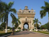
Loas sovereignty
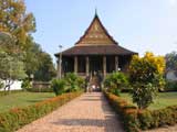
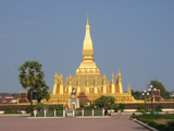
Capital and Seat of the government, it is located in a bight of Mekong River, in the middle of fertile alluvial planes. In spite of its troubled past, it is a quiet town with some beautiful wat and some lively markets. The Pha That Luang (Great Sacred Stupa), symbol either of the sovereignty of Laos or the buddhism, is the most important monument of the country. Its complete official name is: Pha Chedi Lokajulami, which means: "sacred stupa of world value", and on the national seal an image of the main stupa appears. When the king Setthatirat had made move the capital of Lan Xang from L.P. to Vientiane, in the half of the XVI century, he ordered the realization of Pha That Luang with the aspect that we see still today on the site of the khmer temple. The works for the construction of the monument started in 1566 and, in the following years four wat were built around the main stupa, one on each side. Nowadays only two are left, Wat That Luang Neua, on the northern side, and Wat That Luang Tai, on the southern side. Wat That Luang Neua is the residence of the supreme patriach of the laotian buddhism. The main building is, on the contrary, a rebuilding that dates at the beginning of the XX century. Pha That Luang is located 4 Km. north-east from the centre of Vientiane, at the end of Thanon That Luang. In front of the complex stands a statue of the king Setthathirat. The temple is the seat of a grand religious manifestation that takes place at the beginning of november.
Wat Si Saket, built in 1818 by Chao Anou, is maybe the most ancient temple in Vientiane, still visible today. In spite of the evident siamese influence, Wat Si Saket presents very original different elements . The inside walls of the cloister contain small niches with more than 2000 images of Buddha, in silver and baked clay. Moreover, more than 300 statues of buddha, sitting or standing, of different sizes and materials (wood, stone, silver or bronze), are lined up along the shelves under the niches. Most of these statues are carved or melted in the characteristic laotian style. Many of these images were created in Vientiane during the XVI and XIX centuries, but some come from Luang Prabang, and date a period between the XV and XVI centuries. The floral decorations of the ceiling in the sim (room of the ordination) are inspired to the siamese temples of Ayuthaya, that in their turn were inspired to the decoration motives of Versailles. Inside, at the end of the sim, it is possible to see an altar with many images of Buddha, that bring to 6840 the total number of the dipictions inside the Wat Si Saket.
Haw Pha Kaew, in the past was a royal temple, intentionally built to shelter the very famous Emerald Buddha, nowadays it is a museum of sacred art. The building is 100 meters to the south-east of Wat Si Saket.
*****
Don Det island
The province of Champasak, with the plateau of Bolaven, the Si Phan Don islands that emerge from Mekong River and the Wat Phu Champasak, is one of the most visited in Laos and the borders of Cambodia and Thailand make the access easier. Nowadays the province of Champasak has a population of about 500 thousand inhabitants composed by lao from the planes (among whom many Phu thai), khmer and a series of minorities mon-khmer, settled over all in the region of Bolaven Plateau. Paksè is the capital of the Champasak province and was founded by the French in 1905 as administrative centre. The town developed very quickly after the construction of the lao-japanese bridge above the Mekong in 2002, and this has considerably increased the business with Thailand. Thanks to its position on the way to Si Phan Don in the south, the plateau of Bolaven and the farther oriental provinces in the east, and Thailand in the west, Paksè becomes an almost obliged destination for whoever travels in the south of Laos. The airport of Paksè is located 3 kilometers from the town. Lao Airlines daily fly from Paksè and Vientiane (USD 90 one way, 1 hour) The bus to Vientiane (USD 14,50, 9 hours and half, 716 Km.) leaves every day at 8.30 pm., is provided of aircon and bathroom, and the dinner is served on board by a hostess; tickets can be bought at the bus office KVT - Champasak shopping centre - just in front. 8 km. to the south of the town there are the ruins of Wat Phu Champasak, that dates the time of Angkor, and is the most interesting place to be visited. The ancient religious complex of Wat Phu is one of the unavoidable destinations for whoever makes a trip to Laos. Wat Phu spreads out on the lower slopes of Phu Pasak (more commonly called Phu Khuai), and even if smaller compared with the monumental sites of Angkor period in Siem Reap (Cambodia) or of Buriram in Thailand, it is very striking. Its pavillions in ruins, the sanctuary of lingam Shiva richly decorated and the mysterious stone of the crocodile, grant to the temple an aura of mysticism, transfigured by the plays of lights and shadows created by the leaves of the trees. In 2001 the site has been declared by UNESCO a heritage of mankind. The right date of its foundation is still unclear, but many historians think that the structures that survived were started during the reign of Chenla (from the VII to VIII century) and ended towards the end of Angkor period (from IX to XIII century). For the moment the imposing project to rebuild some parts of Wat Phu came to nothing. Nevertheless, other works have been done, financed by the japanese government and leaded under the supervision of UNESCO, to divert the water from the site and consequently to reduce to the minimum the damages caused by wash. Within the limits of this same project a magnificent museum has been built near the ticket office. Wat Phu of Champasak is 46 Km. from Paksè, and 10 Km. from Champasak.
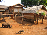
For some impenetrable reasons, the more we go to the south of Laos, the more the atmosphere is relaxed; and then when the pressure is reduced to the minimum, at last we reach Si Phan Don... letterally it means "4000 islands". Along this wonderful stretch of Mekong river, 50 Km. long, the islands are so relaxing that we can spend all the time to rest on a hammock. During the rain season this stretch of river reaches a width of 14 Km., the largest of its course of 4350 Km. from the highland of Tibet to the Southern Chinese Sea. During the dry season, between a monsoon and the other, the river subsides and let appear hundreds (or thousands, if we count also the sand tongues) of islands and islets. The biggest among the permanent islands are inhabited all the year long and offer the fascinating opportunity to know the quiet life of the villages, regulated by the Mekong river. The communities are self-sufficient; they produce rice, sugarcane, coconuts and vegetables in large quantity that covers almost completely their needs, they fish in the river and weave their material. The French left a short stretch of railroad, nowadays not in use (the only one that was completely finished in Laos), a pair of river wharfs and some colonial villas on the islands of Don Khong, Don Det and Don Khon. Among the natural beauties it is possible to admire some waterfalls and violent rapids in the nearby of the cambodian border, where the riverbed of Mekong suddenly lowers its level, and rare species of fresh water dolphin .
Don Khong
This big island, that measures 18 Km. in length from north to south, and is 8 Km. wide as top limit, takes the name from the river that surrounds it. Most of its 13 thousand inhabitants live in the two villages of Muang Khong, on the oriental coast, and of Muang Saen, on the western coast, linked by a 8 Km. street. In Muang Khong there is the biggest choice of guesthouses and restaurants and pleasantly quiet atmosphere; in any case, in every point of the island you are rarely disturbed by the noise of vehicles. The accomodations in Muang Khong are definitely of higher level, compared with those in Don Det or Don Khon, and generally they offer a good comparaison between quality and price. Almost all hotels and guesthouses rent bicycles for 1 USD a day and have the restaurant. Villa Muong Khong Hotel is considered the best on the island, nevertheless, for personal experience, I can say that for the same price or even less the Mekong Guesthouse or the Auberge Sal Done Khong offer larger and cleaner rooms.
By boat you can go to visit the islands Don Det and Don Khon from Khong island. The trip lasts about one and half hour. In both islands there are no cars, no electricity, at least until today, no TV, but an absolutely intact environment. Here you have time to read books, to chat with the local people and with other travellers, to make excursions by bicycle, to admire the landscapes, and idle on a hammock. In other words you can completely relax ! Don Det and Don Khon, located in the south of Don Khong, near the cambodian border, during the colonial french period were important connecting channels for the supply between Saigon and Laos. In order to avoid the rapids and the waterfalls of Mekong river, the French built even a narrow-gauge railway between the two islands, linked by an arch-bridge with cement wharves at the ends. The boats coming from Vietnam and Cambodia unloaded the goods at the southern end of Don Khon; from there the trains carried the goods until the northern landingplace of Don Det, where other boats with destination to the northern towns were waiting. The railroad fell in disuse from the Second World War. The big bridge and the wharves are still undamaged, but many stretches of the rails have been removed by the local people that have recycled them as pedestrain bridges on streams and gorges. Don Khong, the biggest of the two islands, is famous in the whole Laos for the coconut, bamboo and kapok cultivations. In Don Khon you can do an interesting excursion of 5 Km. across the island following the old railroad. During the excursion by bicycle you cross rice fields and small villages.
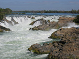

Khon Papheng waterfalls, Bolaven plateau
and its villages
In the south of Don Khong, on the Mekong River, 13 Km. of rapids with many waterfalls follow one another. The biggest one, Khon Papheng is located in the nearby of the oriental bank of Mekong river, near Ban Thakho. From the bank, a nice wood pavilion gives you a wonderful sight on the waterfalls. Often it is possible to meet children that go hunting balm-crickets with a small plastic bag at the end of a bamboo cane. Obviously this is not a game, but a way to earn one's living. In the vicinity of the waterfalls, there are huts with stalls that display the products of the local handicraft, and local restaurants.
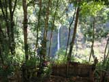
The fertile Bolaven Plateau, which covers the north-oriental area of Champasak province, is renowned for its fresh climate, its waterfalls, its richness of the soil and the first quality coffee plantations, but it is also known to have been one of the most bombed places during the second Indochina War. The zone started to be intensely cultivated at the beginning of the XX century, when the French started coffee, cautchouc and banana plantations. Many french farmers left the plateau when Laos became indipendent in the 50ies of the last century, and those that remained escaped in the 60ies, when the American increased their air raids. Nowadays, Laotians started again to cultivate with enthusiam coffee, fruits and rattan. On the plateau, besides the laven live other mon-khmer ethnic groups, like alak, tahoy and suay. The villages of katu and alak groups distinguish themselves for the typical houses with palm leaves and straw arranged in a ring. A typical custom of katu is to build a wooden coffin for every family member much time before the death; coffins are kept under the rice roofs until the moment they will be used. A pecularity that joins the alak, katu and laven is to tatoo the women's face, a habit that is little by little disappearing under the growing influence of lao people in the zone. Many katu and alak villages are located along the road between Paksè and Paksong, at the western sides of the plateau, and on the dirt road that goes down from Muang Tha Taeng, on the plateau, to Beng, in the province of Salavan. Among the many waterfalls in this zone, the most visited are those of Tat Fan, just a few kilometres to the west of Paksong, of Phasoume Resort and Tat Lo, on the route 23 to Salavan.
Laos currency
: Kip
Exchange rate on 17th of February 2006:
1 € = 12.300 Kips - 1 USD = 10.350 Kips